“Maps don’t merely show the world, they make it”– Jane Jacobs. Despite all the talk of cyberspace and global trade, geography still decides the fate of nations. From the air corridors over Cold War Berlin to the frozen ridges of Kashmir, from Russia’s drive through Ukraine’s plains to Gaza’s claustrophobic strip of land, geography remains the most brutal dictator of world politics.
We may live in the age of artificial intelligence and quantum computing, but states still fight over the same things they always have, i.e., land, water, and access. Globalization dreamed that maps would matter less; the reality is that they matter more than ever.
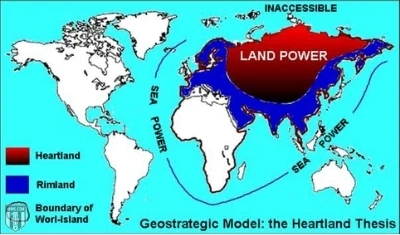
The Old Masters Were Right
A century ago, the British geographer Halford Mackinder warned that whoever controlled the great Eurasian landmass, the Heartland, would command the world. His rival Alfred Mahan argued that true power lay at sea, in control of ports and maritime routes. Their ideas were the skeleton of strategy itself. Even in 2025, their ghosts haunt war rooms and policy circles. Commanders still plan around topography, not tweets. States still fight for corridors, coasts, and straits.
Technology changes how wars are fought, not where they’re fought. Drones, missiles, and satellites still rely on ground bases, ports, and airfields. Cyber power still runs through undersea cables, proving that even the digital world is ruled by geography. The medium evolves; the map endures.
Berlin: The City that Defied Geography
When the Soviets blockaded West Berlin in 1948, the city became the world’s most famous island, a Western enclave trapped 160 kilometers deep inside Soviet-controlled territory. For the Allies, geography was a noose, not an abstract concept. The roads were cut, the rails blocked, and only the sky remained open.
What followed the Berlin Airlift was an extraordinary feat of logistics, a defiance of distance and siege. But its real lesson was simpler: even with all their power, the Western Allies could not change the map. They could only work around it. The city’s isolation turned geography into a weapon, one that forced a superpower to feed an entire metropolis by air for almost a year. Berlin proved a timeless truth and says that when politics and geography collide, geography almost always wins.
Kashmir: Where the Mountains Dictate the Map
If Berlin was about isolation, Kashmir is about altitude. A conflict carved into the Himalayas. The Line of Control snaking across glaciers and mountain passes isn’t just a political boundary but a daily logistical nightmare. Soldiers fight both their enemies and the mountain itself. The terrain favors defenders, punishes movement, and makes demilitarization nearly impossible.
But Kashmir’s geography doesn’t stop at rock and ice. It flows in water. The Indus River system, fed by Himalayan glaciers, sustains life across Pakistan. Its control has been so vital that both India and Pakistan had to bind themselves to the 1960 Indus Waters Treaty. It is one of the few diplomatic pacts that has survived every war between them. Rivers are geography’s most patient negotiators. They remind rivals that nature does not yield to nationalism.
Ukraine: The Flatlands of Attrition
Look at a satellite image of Ukraine and you’ll see a geography that seems made for invasion. It shows vast open plains crossed by a single great river, the Dnieper. But in modern war, that openness has become a curse for attackers. Russia’s forces, like Napoleon’s and Hitler’s before them, discovered that in these flat lands, visibility is death. Drones see everything, artillery reaches everywhere, and the absence of cover turns maneuver into a massacre.
The Dnieper divides the country not just politically but strategically. This massive natural barrier shapes every military move. Control of bridges and crossings determines life and death. And beyond the river lies the Black Sea, Ukraine’s economic lifeline. When Russia blockaded its ports, it shook global grain markets and starved Africa and the Middle East. A single coastline can shake the global economy, showing that one nation’s map shapes us all.
Gaza: The Geography of Confinement
Nowhere is geography’s cruelty more visible than in Gaza. A small strip of land, barely 40 kilometers long, surrounded by walls, watchtowers, and the sea. Every road ends at a checkpoint, and every breath depends on a permit. Gaza is under siege.
When Israel sealed its borders and the world looked away, the people of Gaza were forced to survive within the narrow lines drawn around them. Denied land, sky, and sea, they turned underground. Those tunnels the world talks about are arteries of life carrying food, medicine, and hope beneath a land denied the right to breathe. Here, geography decides who lives and who doesn’t. Each bombing redraws the map, and each border closure tightens the noose. In Gaza, walls replaced horizons. It’s a survival against the geography of control.
Chokepoints: The World’s Pressure Valves
Zoom out, and the same logic scales up. Every oil tanker that passes through the Strait of Hormuz, every container ship through Malacca or Suez is proof that a handful of narrow waterways sustain the global economy. A missile fired near Yemen can raise fuel prices in Karachi and London. Geography doesn’t just dictate war; it dictates wallets. These narrow straits have become the new frontlines of global competition. The 21st century’s battles may be digital, but their consequences travel by sea.
Technology’s Mirage
Every decade brings prophets of the end of geography. They said airpower would make borders irrelevant. Then nuclear weapons. Then globalization. Then the internet. Now it’s AI. However, the irony is that each innovation tightens geography’s grip. AI depends on data centers, which require land, power, and cooling. Satellites rely on ground stations and orbits controlled by sovereign states. Quantum labs and chip foundries cluster in physical corridors from Taiwan’s coastal belt to California’s Silicon Valley. The new great game over semiconductors, rare earths, and sea cables is nothing more than geography reborn in digital form. Mackinder would smile: the map never died; it just moved online.
The New Frontiers: Ice, Sea, and Sky
Even the Arctic, once a frozen void, is becoming a geopolitical arena as melting ice opens new shipping lanes and exposes untapped oil reserves. China, a non-Arctic state, now calls itself a “near-Arctic power.” The United States is scrambling to deploy icebreakers and bases. Climate change is not erasing geography but redrawing it. Control of the poles, the seabed, and the skies above them is fast becoming the 21st century’s version of Mackinder’s Heartland.
What the Map Teaches
If geography dictates conflict, it must also dictate peace. Understand that bridges, tunnels, and trade routes are as strategic as missiles. When geography divides, diplomacy must draw new maps because borders can reflect justice or oppression, but they always have consequences.
To conclude, the cartographer always has the final veto. Empires may rise and algorithms may hum, but the oldest lines on our maps still write the first chapters of war. To ignore them is not just to forget history, it’s to invite it to repeat itself. Geography, brutal and eternal, still rules us all.